The
next chapter in our annual reviews of weather moves on to 2008, a
year which brought some wonderful surprises but also some terrible
disappointments. The surprises included a heavy spring snowfall in
the capital city of London and a good start to the summer. However,
disappointments included a rapid decline in summer weather whereby
the holiday months of July and August saw very few dry and warm days.
It was also the year that the EOTS team returned to Florida to take
on some afternoon tropical thunderstorms.
This
section sums up the year for us, by displaying a number of photos
from the most significant weather events we encountered during each
month.
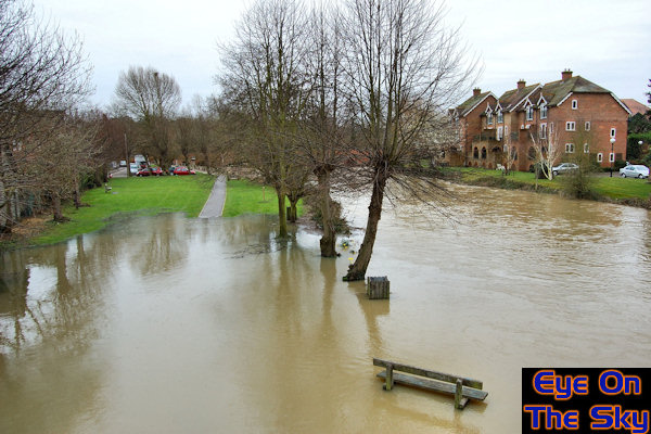
January
2008 - Warm
& wet - mostly
The UK was dominated by west or south-westerly
winds for a good part of January, resulting in a mild and often wet
month. Rain was always heaviest in northern and western parts of the
country but even in the south-east, there were a series of heavy rains.
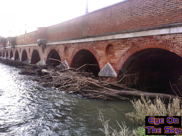
One such downpour took the River Mole in Surrey to breaking point.
Our photograph below shows the Mole through the town of Leatherhead.
Just a couple of days earlier, the river level was very close to the
top of the arches, where it piled up trees and branches against the
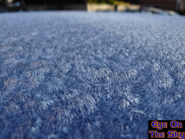
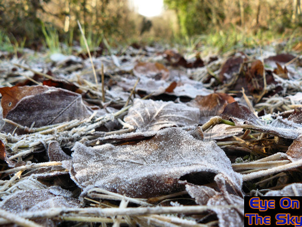
bridge. There were some colder, settled periods during the month too,
which saw occasional frosts develop. The second two images show the
morning after the night before, with needles of hoar frost sitting
deep on car bodywork, and on fallen leaves in the North Downs.
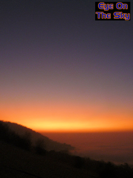
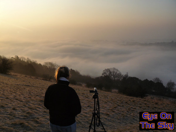
February
2008 - High
pressure highlights
The month couldn't have differed more spectacularly
from January, with low pressure departing to leave the UK in the grip
of high pressure for a good part of the month. Conditions were dry
and settled for a number of weeks although the weather type gradually
shifted as time went on. In the sunshine, it was initially very warm
for the time of year but as the air stagnated, frost and fog became
more of a feature, the fog not shifting all day in some areas. With
increasingly cold air aloft, an unusually feature became apparent
between 18th and 20th of the month. Normally seen closer to the poles,
stratospheric clouds meandered their way slowly across the UK, trapped
within the anticyclone. Whilst invisible during the daytime, they
lit up in spectacular fashion during the evenings and mornings, making
for sunsets and sunrises which made the national press. The first
image below shows one such sunrise from the summit of Box Hill in
Surrey, with fog trapped in the valley below. The second photo shows
another view of the fog in the Mole Valley, which was freezing in
places, leading to rime ice and frost. A timelapse video of the sunrise
and fog can be found in our video
section.
March 2008- Ark
requirements
After February's break in the weather,
March would see a return of very unsettled and very wet conditions.
Whether in the form of heavy showers or longer spells of rain, most
places received a good soaking at some point. On the 9th/10th, an
unusually violent storm brought significant flooding and strong winds
to south-western portions of the UK. As the first image shows below,
this coincided with the Severn Bore, driving a wall of water into
the Bristol Channel and inland to Gloucester. We've put together a
documentary video as we followed the bore upstream, in our video
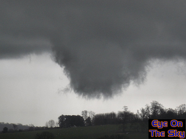
section. Heavy showers
made their way across the UK, some with thunder. The second image
below shows a weak thunderstorm as it crossed north-east Surrey. It
produced a suspect lowering which was observed to rotate as it disappeared
over the hillside. The final image below sees a return to the River
Mole after further heavy rain. This time it burst its banks with ease,
flooding surrounding land. The flooding was mild here in Leatherhead,
but in the surrounding countryside, vast tracts of farmland disappeared
beneath the water.
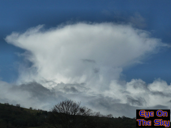
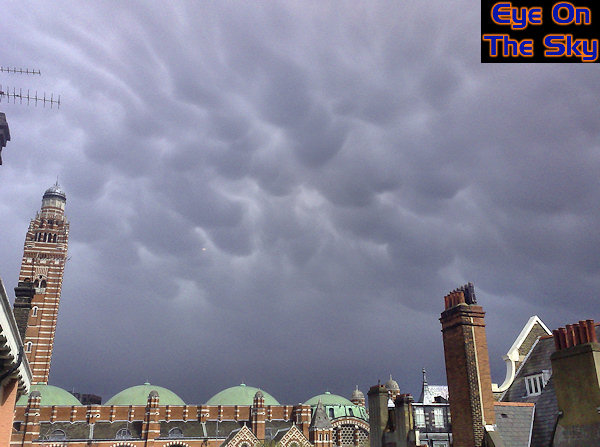
April 2008 - Hurrah
for the snow!
The month began in spectacular fashion
as warm conditions were swept aside by a vigorous northerly flow.
A line of snow moved southwards across just about the whole country
during the night of the 5th, arriving in the south-east early on the
6th. This provided south-east England with some of the heaviest snowfall
in years. We measured 10cm of level snow in Leatherhead although some
areas had more. The first three images below show our journey home
from London after a night shift as the snow accumulated in a surprisingly
short space of time. The rest of the month was dominated mostly by
unsettled and showery conditions, and with the heat of early spring
beginning to add more energy to the system, the showers were often
heavy and thundery. The 4th and 5th images below show some of these
showers, with an impressive anvil in north Wales and amazing mammatus
on the underside of a thunderstorm in London.
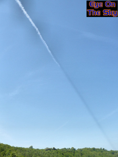
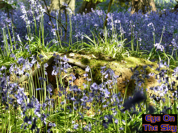
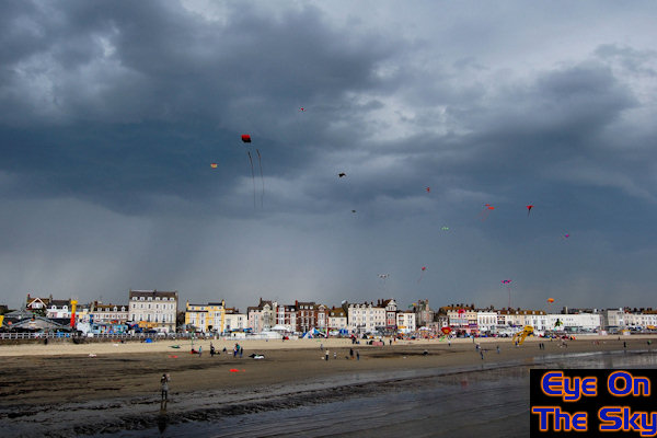
May 2008 - Spring
springs
The start of May saw high pressure
and south-easterly winds across the southern half of the UK. As
a result, it was warm and sunny for a good week or so, which really
allowed spring to accelerate across the UK. The first two images
below show a couple of day's worth of this fine weather, with warm
sunshine over the North Downs, and a strange contrail shadow over
Arundel in West Sussex. The third image shows the effect of this
sunshine, allowing woodland bluebells to explode into life. However,
it wasn't all plain sailing. As the south-easterly wind brought
in more and more humidity, scattered thunderstorms developed. The
fourth photograph below shows one such storm over Weymouth in Dorset.
The EOTS team were due to be filming a few scenes for a BBC documentary,
"Britain From Above" at the Dorst kite festival but this
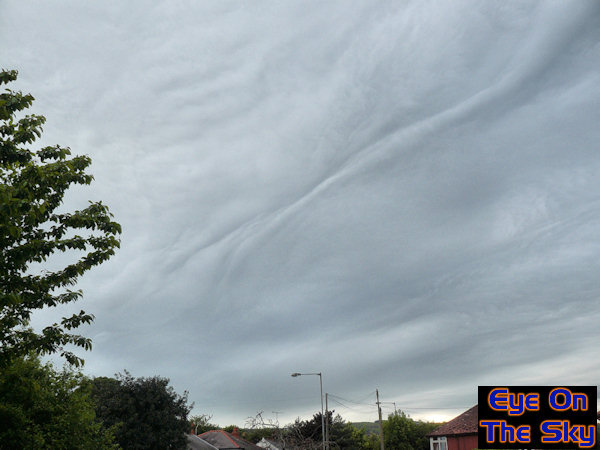
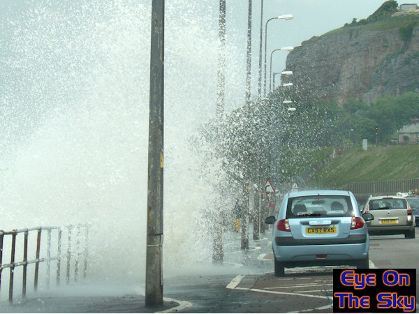
storm put pay to that! Towards the end of the month, conditions
became more unsettled as low pressure took control. One such depression
brought strong winds and heavy rain to north Wales. The fifth image
below shows the pre-rainfall cloud structures with unusual lines
across the sky. The sixth image shows the effect of the strong winds,
as waves battered their way over the promenade at Rhos-on-Sea in
north Wales.
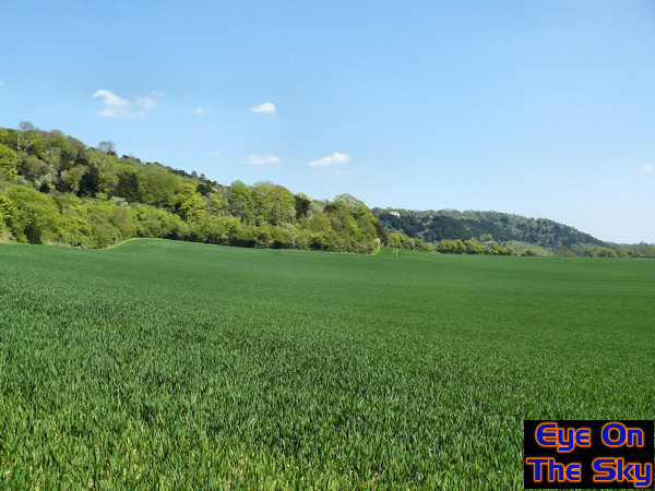
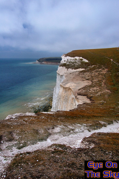
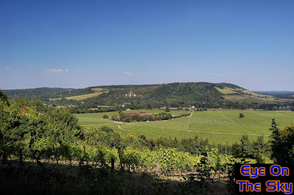
June 2008 - Not
a lot to write home about
June will go down as forgettable across
the south-east of England. In general, there was a lot of dry weather
around but often a lot of cloud and it wasn't especially warm. Other
parts of the UK, especially the north-west, saw plenty of rain and
strong winds but it was much quieter in the south-east. As a result,
weather photography was thin on the ground, and comprised mainly of
landscape shots during the sunny spells, such as those below. The
first image shows a view from the Seven Sisters in East Sussex, during
a typically bright but cloudy day. The second image was a scene right
out of the south of France, except the view is over Denbies Winery
in Surrey during a sunny day.
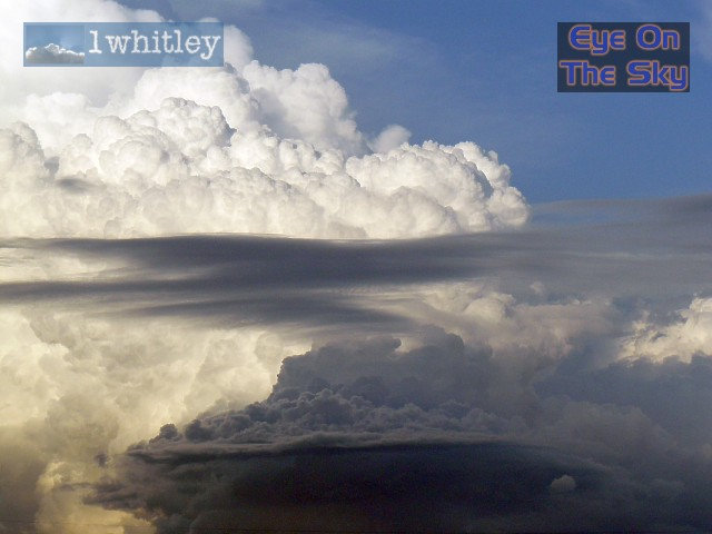
July 2008- UK
storms and Stateside chasing
The start of July saw the EOTS team return to
Florida for another session of storm chasing in the Sunshine State.
Once again, the trip was a roaring success, with too many storms to
count and lots of weather action. The first few images below show
just a small selection of some of the action we caught up with. For
a full photographic report visit our chase
section and for a feature length video of the chase highlights,
visit our video
section. However, there was plenty of storm action to keep us amused
back in the UK for the remainder of the month. One such stormy day
saw almost Floridan-style 'popcorn' storms light up across southern
England. The last couple of photos below show some scenes from these
storms, including bubbling convection and a marked gust front.
August 2008 - Stormy
summer continues
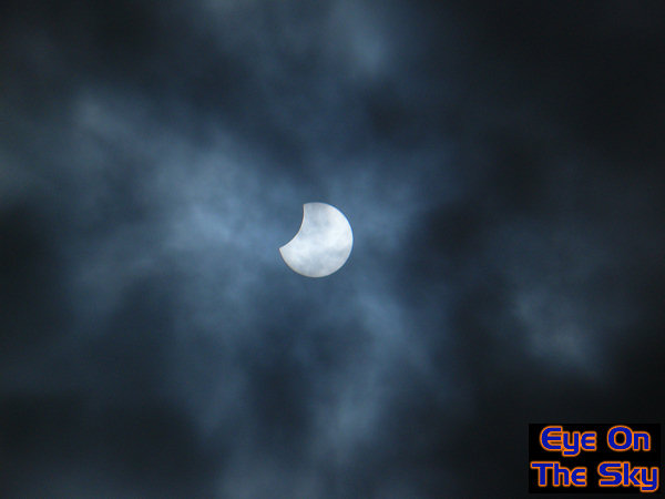
The unsettled and rather cloudy summer continued
through August, with persistent depressions bringing rain or showers
across the country. There was precious little sunshine which only added
to the poor feel of things. There were some sunny spells around though,
and on the first day of the month, hazy sunshine came through just in
time to witness the partial eclipse, as seen in the first image below.
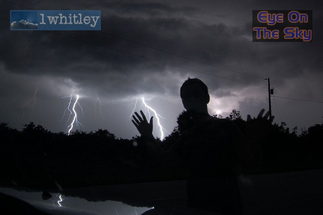
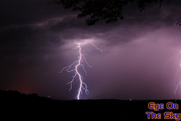
Towards the middle of August, there was a very temporary Spanish Plume
episode which brought warm conditions into the south-east corner. No
sooner had it arrived, it had gone but it went with a bang. As the second
image below shows, a line of nasty thunderstorms moved north across
the south-east corner and we chased the storms into the night, getting
some great lightning shots. Right at the end of the month, the EOTS
team were in Devon for the Dartmouth Regatta. The weather was dry but
it was very humid, producing misty low cloud. The Typhoon fighter jet
was pulling some turns over Dartmouth, and the moist atmosphere was
creating water as the plane passed by. The last image below shows clouds
condensing over the Typhoon's wings.
September
2008 - Summer
sun & floods
We were still camping in Devon during the first
few days of September. As the first image below shows, the weather
was beautiful. We even had some warm sunshine and an overnight thunderstorm
to keep us amused. However, by day 5 of our trip the weather took
a turn for the worst. The rain came down and simply didn't stop, essentially
flooding us out, as the second image shows. This sent us scurrying
home ahead of time. We returned home to Surrey to find ourselves amidst
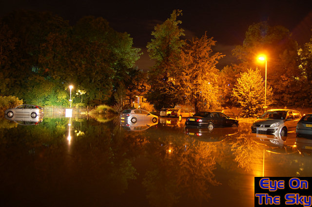
more torrential downpours. One such storm on the 6th brought flooding
to the centre of town, and as shown in the third image, some cars
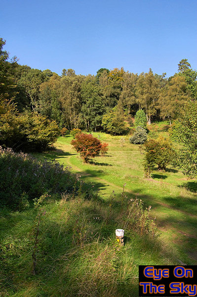
were stranded by water over 2ft deep in places. The middle of September
saw high pressure dominating with a return of a late summer. It was
warm and sunny - significantly better than at any point during July
or August. The fourth image is taken at Winkworth Aboretum in Surrey,
with azure blue sky and lots of sunshine. It became cooler again towards
the end of the month.
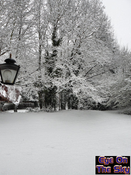
October
2008 - Autumn
warmth then autumn snow
October began rather cool and unsettled
with several fronts bringing rain to all. However, by mid month, high
pressure across the south of the UK brought some very warm and sunny
weather, with 23C recorded in the south-east on the 12th. This allowed
autumn leaf colour to really explode through the week to follow. The
two images below show this wonderful orange autumn on Ranmore Common
in Surrey, part of the North Downs. Just two weeks later, in the last
week of October, winter arrived rudely and abruptly. An extremely rare
October Arctic blast sent bitterly cold air tumbling across the UK,
resulting in night frosts and cold days. Not only this, but it was an
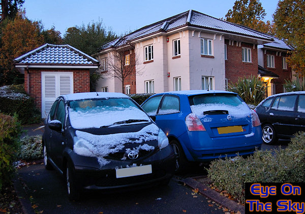
unstable northerly with snow falling in many areas. Parts of southern
England saw their most significant October snowfall in 70 years on the
night of the 28th-29th. Over an inch fell in hillier areas whilst, in
our town of Leatherhead, around half a centimetre dusting of snow on
the cars and grass greeted morning commuters. The last two photos show
this dusting of snow in Leatherhead which, despite it's small amount,
lasted for 48hrs due to the very low tempeatures.
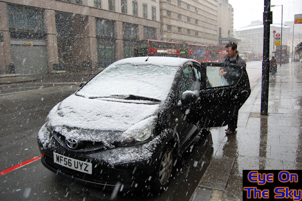
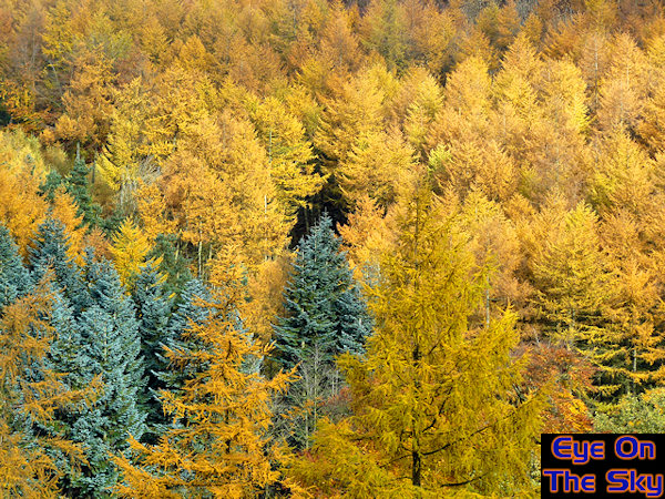
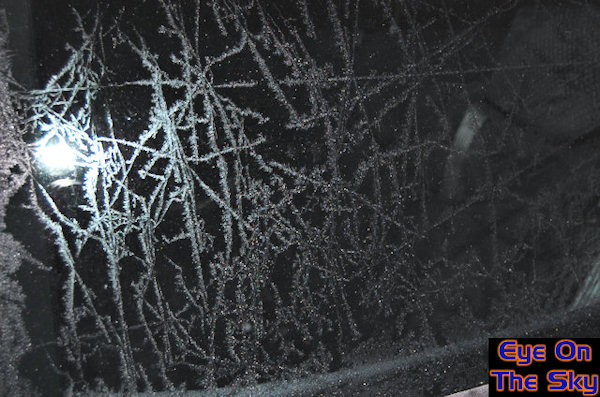
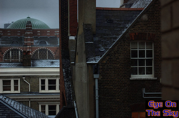
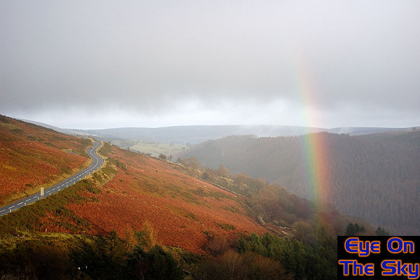
November 2008 - Autumn
into winter
The month began rather chilly and cloudy, with
no real photogenic weather going on in the south-east of the UK. Into
the second week, we spent a short break in north Wales just as the weather
began
to come in from a westerly direction, which is a classic for sunshine
and showers. The first image below show our trip to World's End near
Llangollen, and we managed to capture a rainbow briefly over the cliffs.
Autumn was still in full swing and the trees were giving a magnificent
display. The second image below shows some glowing pine trees near Llangollen,
surrounding their neighbouring evergreens. After a mild period mid-month,
winds began to come in from a more northerly direction leading to a
much colder last week or so. Night frosts were common even in the south
of England, as shown in the third image below, with needles of hoar
frost spidering their way across our car. On the 23rd of November, a
widespread snowfall event affected large parts of the UK, including
central and southern England, as milder air attempted to come in from
the west. It even snowed in Central London, as shown on the fourth image,
although amounts were small compared to other parts of the UK. This
was the second snowfall in London in quick succession, the first being
in October, and it wasn't even winter yet!
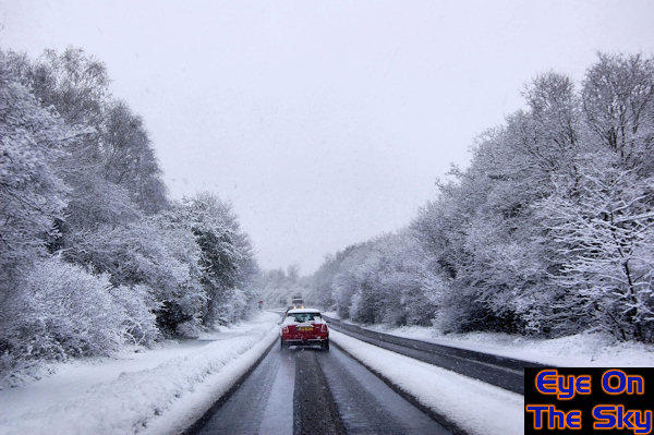
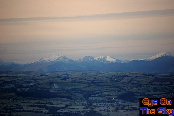
December 2008 - Lots
of cold but no white Christmas
The first few days of December were unsettled
and cold across southern areas, with rain at times. Where any clear
skies persisted overnight it became very icy. The first image below
shows one such icy morning after a fall of rain the evening before,
and the patterns on car roofs were quite impressive. It remained cold
into the second week as high pressure built across the southern UK
and this allowed another session of night time frosts, together with
freezing fog. The second and third images below show the EOTS team
visiting the Clwydian Mountain Range in north-east Wales. Frost and
shallow fog was evident in the valleys below but the cold, crystal
clear air made for spectacular visibility, and as the photos show,
the Snowdonian mountain range looked as if it was on our doorstep,
despite being 50km away. Towards the end of the second week of the
month, the flood gates opened for mild Atlantic air to surge in from
the west, and this would last for some time, bringing wind and rain
across the UK. The fourth image below shows a view on the Horseshoe
Pass in north-east Wales, as low cloud began to clear leaving behind
a very local rainbow! The last ten days of the month saw high pressure
building across the south of the UK, and an area of high pressure
that would go on to dominate the weather into 2009. This brought much
colder conditions across the UK, with widespread night frosts and
freezing fog. Despite the cold conditions, Christmas was largely green!


Will
2009 be a weather year to beat 2008? Here's hoping......

Copyright
eye on the sky 2001-2008
|