The
EOTS team had not long returned from their successful storm chasing
trip to Florida, when some powerful UK thunderstorms decided they was
going to compete for our appreciation! In fact, such was the power and
ferocity of the thunderstorm which struck Weybridge, Surrey, during
the evening of 27th July 2006 that it would easily rival anything we'd
seen in the Sunshine State!
Warm
and very unstable conditions continued across the UK during the 27th,
continuing the sort of setup which saw immense thunderstorms across
East Anglia a day earlier (see "Cambridgeshire
Destroyer"). Through the day, thunderstorms had developed
throughout the Midlands and northern England and were gradually homing
in on south-east England as evening approached. The following synoptic
chart (provided by http://www.wetterzentrale.de
and copyright UK
Met Office) shows the pressure patterns and frontal analysis
for midnight on 28th July, just hours after the storm struck Weybridge:

At around 3pm, a fairly harmless line of cumulus moved gradually eastwards
across central-southern England, connected northwards to lines of thunderstorms
over the north Midlands. The following high resolution satellite images
are copyright Eumetsat
and MeteoGroup
UK, and show the evolution of the thunderstorms as they developed.
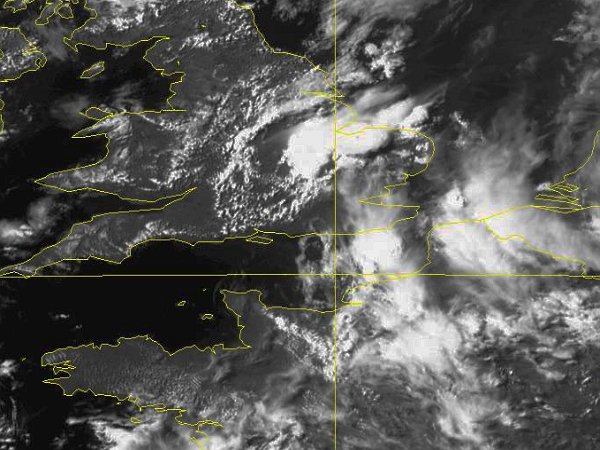
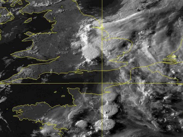
At 3pm, a long line of cumulus clouds stretches back from storms over
the Midlands, towards the Isle of Wight.

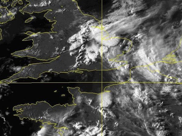
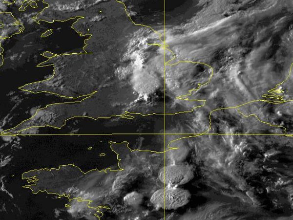
An hour later at 16:00, the line of cumulus suddenly erupts into several
discrete cumulonimbus cells, producing heavy showers. Note the simultaneous
development of thunderstorms across northern France too.
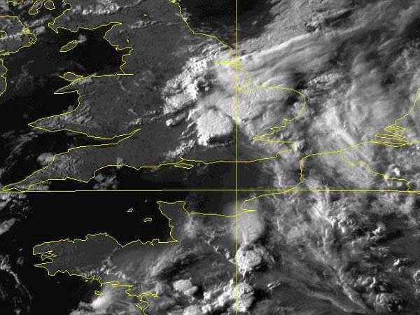
The
initial cell development produces some short-lived thunderstorms to
the north and west of London although these quickly die off. As their
streaming anvils decay as they move northwards, the storms had left
behind a pool of moisture in north-east Surrey, just as the line of
cumulus, stretching back towards the Isle of Wight, moved in from the
west.
Just
30 minutes later at 17:30, the cumulus ingests this moisture and a titanic
thunderstorm erupts over northern Surrey. The updraft was to the west
of Weybridge at this time, and can be seen here on the southernmost
edge of the storm. The thunderstorm's huge and solid anvil can be seen
streaming northwards into the east Midlands. Note the outflow boundary
line of cumulus already heading south-eastwards away from this monster
of a storm.
The thunderstorm upraft reached Weybridge here at 18:00, and began to
regenerate on its southern flank in a spectacular back-building manner.
As each updraft erupted and moved north, a new one would develop over
the village. This process repeated itself between 5 and 7 times, with
each new cell reinforcing the thunderstorm. The 'V' shape of the thunderstorm
is almost text-book in appearance, with the sharp updraft on the southern
edge complete with the feeding flanking line to the south-west, and
the raging anvil spreading out northwards. In an identical manner, note
the lines of cells erupting into giant mushrooms over France.
This
image from 18:15 shows beautifully how the new cells were developing
on the southern side of the storm. This particular updraft would provide
the finale over Weybridge, with rainfall like the EOTS team had not
seen in this country, and lightning every 5-10 seconds.
The
EOTS team arrived into Weybridge train station just as the thunderstorm
began unloading its contents over the village and surrounding area.
The following account shows photographs from this event.
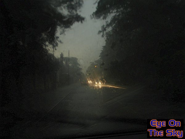
This
is the scene that greeted us as we drove back through Weybridge; daytime
darkness, torrential rain and flooded roads. The only daylight was provided
by the lightning!
No
enhancements have been carried out on this image, except to increase
the brightness! Conditions really were like the dead of night as the
thunderstorm sat overhead.
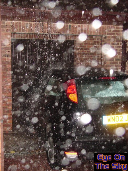
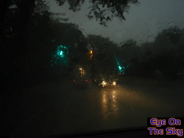
We
had never seen rain like this in the UK before. It came down in
torrents, overpowering guttering and causing rapid flooding.
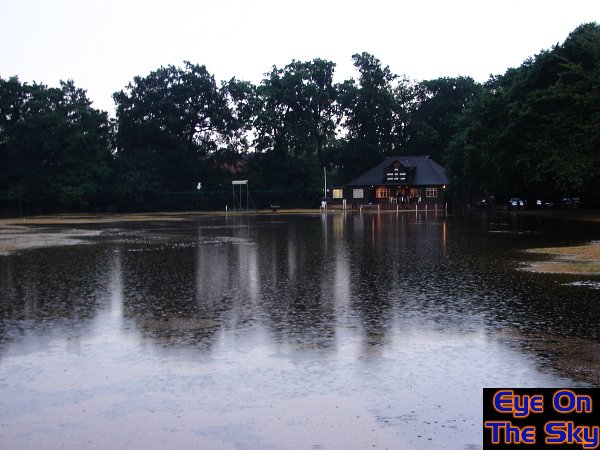
As
the first cell moved away, and in the short break before the next developed
overhead, we took a quick walk around and were greeted with this scene
on the local cricket green!
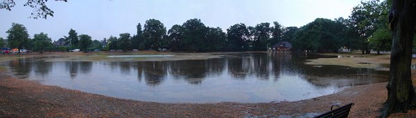
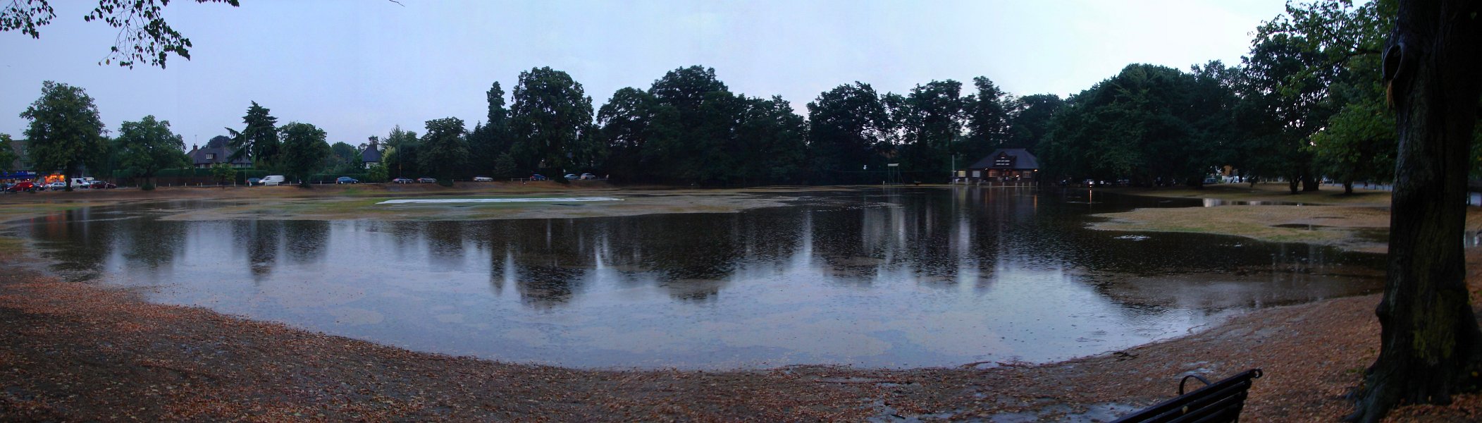
Here
is a panoramic view of the flooded cricket green. Click on the image
for a larger version.
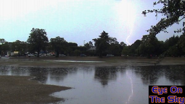
A video capture showing a CG lightning strike, both in the air and on
the water!
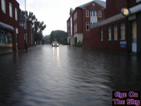
After
several more cells came and went, and the rain eventually eased, we
went for a drive through Weybridge and the surrounding area and encountered
flooding chaos. The whole of the village centre was under water, a
foot deep in places!
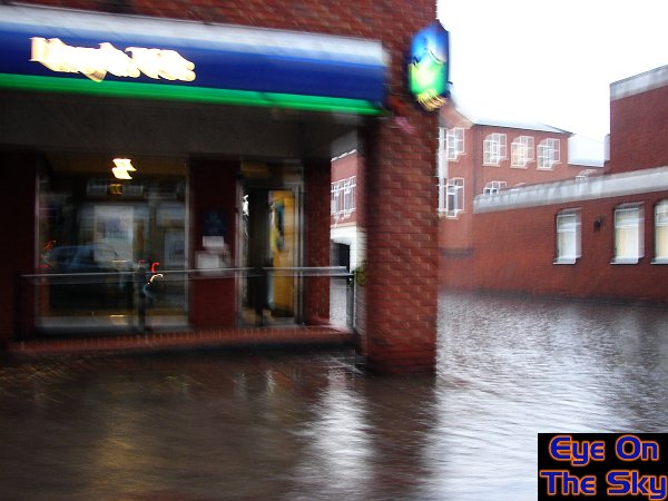
More
flooded roads, with water pouring into shop fronts and buildings.
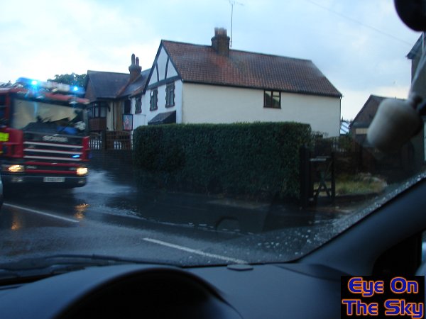
With
closed roads and flooded buildings, the emergency services were out
in force.
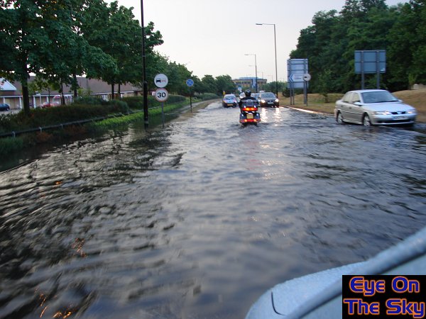
Many
roads were close to being impassable due to flood water.
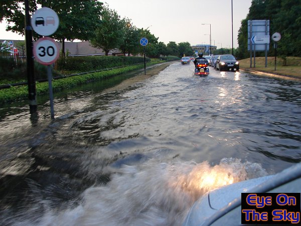
You
know you're in trouble when the water is deep enough to cover the front
lights!
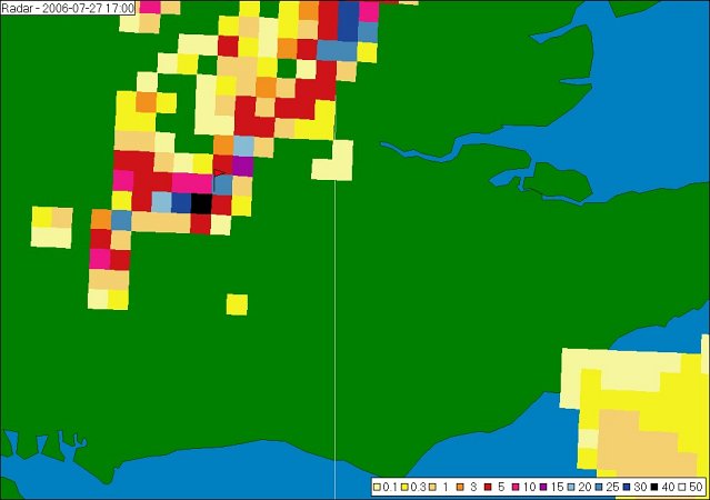
This
was the radar frame at 1700z, where black shows the most intense rainfall.
The red flag marks the position of Weybridge.Radar copyright
MeteoGroup UK
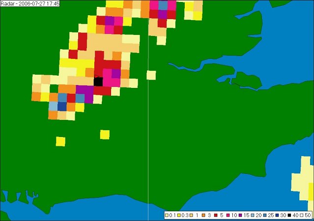
Nearly an hour later, and the intense echo remains right over Weybridge,
corresponding
to where the updrafts were back-building, developing and collapsing.
The EOTS team collected each 5km resolution radar image between
16:00z and 19:00z, and used a technique to estimate the rainfall totals,
based on the radar pixels alone. During the three hour period, we calculated
that 48mm of rain had fallen, 42mm of this in one hour. However, we
managed to obtain the 1km resolution, 5 minute radar sequence from the
UK Met Office (we do not have permission to reproduce this) and the
rainfall estimation over the same period is 82mm, 71mm of this falling
in one hour. Unfortunately, we did not have an accurate rainfall gauge
and thus this is purely an estimate. However, we feel it is a fairly
good estimate based on the intensity of the rain and the resultant flooding.
The
best footage we obtained from this monsterous back-building thunderstorm
was in the form of video, some of which was taken on our digital camera,
and some on our camcorder. The following links are to several of these
videos which give a good indication of the rainfall intensity and lightning
proximity.
Extremely
close CG lightning discharge:
Format:
Windows Media Video (wmv)
Video: 2.36mb, 0:12
A
wander around between storm cells
Format:
Windows Media Video (wmv)
Video: 18.2mb, 1:41
Rainfall
footage from digital camera
Format:
Windows Media Video (wmv)
Video: 8.06mb, 0:44
It
is extremely difficult to put across the shear intensity of this thunderstorm
in photographs and videos. It was without doubt the most intense thunderstorm
we'd ever seen, all taking place right over the top of Weybridge and
lasting for a considerable length of time. Narrow lines of back-building
thunderstorms can deliver a huge amount of rainfall to very localised
areas, and due to the nature of their regeneration over the same spot,
they can last for quite some time.
This
was a spectacular storm which had the effect of making us behave rather
wrecklessly. It's extremely dangerous to wander around outside with
frequent lightning in the area and we do not condone such activities
in any way, shape or form.

Copyright
eye on the sky 2001-2008
|