Thunderstorms
- 1998 to 2001
(Photographs
copyright Eye On The Sky)
 |
| Date:
Winter, late 1998 Location:
Hope Mountain, Flintshire, NE Wales A superb looking Cb complete with anvil and mammatus. This winter shower in late 1998 gave a dusting of snow across Wrexham town, at the same time as dropping lightning bolts! (Photograph taken using an old 35mm camera, then scanned). . |
 |
| Date:
Winter, late 1998 Location:
Hope Mountain, Flintshire, NE Wales Another shower over the same area as the previous, again producing snow and electricity but a day later this time. The sun-lit tops proves every cloud have a silver lining! (Photograph taken using an old 35mm camera, then scanned). . |
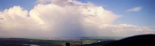 |
| Date:
Autumn, 1999 Location:
Hope Mountain, Flintshire, NE Wales A 2-photo combined landscape image of a huge cumulonimbus which roared across the Cheshire Plain in autumn 1999. This cell produced flash flooding in my village and gave small hail. A larger EOTS Panomotion version of this image is availabe here (requires Java applet). (Photograph taken using an old 35mm camera, then scanned). . |
 |
| Date:
Winter, 1999 Location:
Horseshoe Pass, Denbighshire, N Wales. A monsterous wall of hail and snow is racing over the hills towards me in Winter 1999, dropping lightning bolts as it goes. This shower gave 2 inches of snowfall in just an hour!! (Photograph taken using an old 35mm camera, then scanned). . |
 |
|
Date:
Winter, 1999 Location:
Hope Mountain, Flintshire, NE Wales. |
 |
| Date:
August 2000 Location:
Llay, Wrexham, NE Wales. A funnel cloud lowering from a menacing cloud base in North Wales in August. By the time this was taken, the funnel had retreated somewhat back into the cloud! (Photograph taken using an old 35mm camera, then scanned). . |
 |
| Date:
June,
2001 Location:
Reading, Berkshire. Towering over Reading, a huge cumulonimbus approaches from the north-east, dropping torrential rain and small hail, with frequent CG lightning. The top of the cloud can just be seen at the top right of this image, demonstrating the cloud's immense depth. (Photograph taken using an old 35mm camera, then scanned). . |
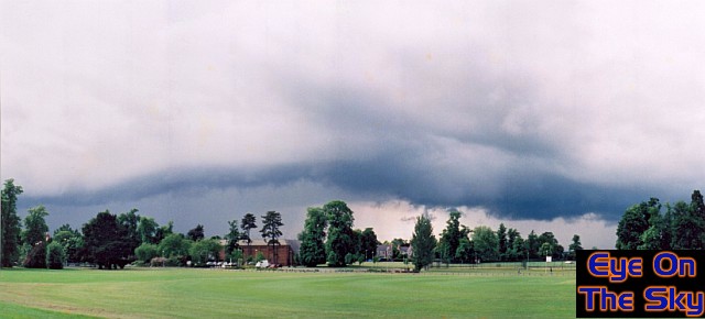 |
| Date:
June,
2001 Location:
Reading, Berkshire. A 4-photo combined landscape image looking from south-west, to north, then round to east. This Reading storm completely enveloped me after this with frequent CGs. A larger EOTS Panomotion version of this image is availabe here (requires Java applet). (Photograph taken using an old 35mm camera, then scanned). . |
 |
| Date:
June,
2001 Location:
Reading, Berkshire. Another view of the menacing storm cloud from my university campus. Ahead of a solid, mature cumulonimbus, mountainous congestus continually sprouts up at incredible speed! (Photograph taken using an old 35mm camera, then scanned). . |