|
>Tree
devastation
NE Wales, January 2007 |
|
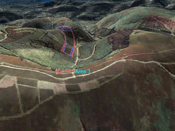
Thursday 18th January 2007 will be memorable across wide areas of England and Wales, as one of the most destructive and widespread gales ravaged many areas, causing huge amounts of damage and taking many lives. During this event, forested areas on the eastern slope of Moel Famau, the highest point in the Clwydian range in north-east Wales, were razed to the ground. Ordinarily, the destruction of these trees could be easily attributed to the gale force winds during the day. However, it is the nature of the felled trees which is interesting, pointing to processes beyond those of normal straight-line winds. Bren visited Moel Famau on 13th February 2007, nearly a month after the gales had taken their toll. The route from the main car-park traverses around the mountain side into a steep-sided river valley. The valley is orientated almost west-east for the most part, with the head of the valley rising to 450m above sea level at its western end. The valley bottom sits at around 350m above sea level, with the greatest incline found very close to the head of the valley. The 3D terrain image below shows the valley in question, with the valley head in the background and the main peak of Moel Famau to the right-centre of the image. Beyond the valley head in the background is the sprawling plain of the Clwyd Valley, which drops to around 50m above sea level.
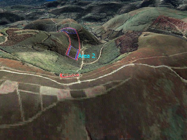
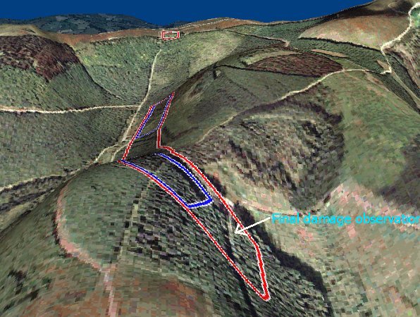
During Thursday 18th January, the strong to gale force wind was predominantly westerly in direction. The valley in question is often very sheltered in westerly flows, and can be considerably warmer than areas on the western slopes of the Clwydian Range. However, on the 18th a process must have been evident which allowed damaging winds to pass over the high ground at the head, into the valley itself. The next few images show the valley in aerial and 3D orientations, from various angles. The red boxes show where there was significant tree destruction, and the blue boxes show where tree destruction was almost absolute, with few trees left standing within those areas. All images are copyright Memory-map.
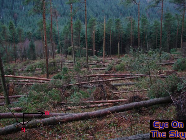
Many images were taken of the felled trees. Some of these are displayed below, and are referenced to each individual area. Area 1: The head of the valley
The forest starts very abruptly close to the top of the ridge, before cascading down the eastern flanks of the Clwydian Range. The trees on the western limits often take a pounding from strong westerly winds, and this time around was no exception. However, one particular area of trees, close to the head of the valley, were damaged to a far greater degree than anywhere else along the tree line, as shown below:
Area 2: Total destruction on left-hand hillside of valley.
Between the head of the valley and Area 2, the steepest descent is evident. Within the area of forest on this steep slope, there was no damage evident to trees whatsoever. However, damage immediately commenced at the western edge of Area 2, and it was stunningly abrupt. The following images show some of the almost complete tree devastation within Area 2:
From this point onwards, the damage track began to curve around the outside of the hillside. This was observed as the track turning from an easterly direction into a north-easterly direction, gaining altitude all the time. Damage was not as widespread within this zone, although a rough estimate would suggest that around 30-40% of trees in this area had been uprooted or snapped. Area 3: Approaching summit of valley side. As the following 3D map shows, the damage path now turned slightly north-eastwards up the valley side, eventually passing over the summit of the valley.
As mentioned earlier, damage was less extensive during the climb up to the top of the valley side. However, on arriving near to the summit, damage became near-total once again, as the following images show.
Just
over the top of the valley side, the terrain drops sharply into another
valley which is orientated from south-west to north-east. There was
some damage to the tops of the trees at the higher reaches of this valley,
before damage ceased altogether. The following 3D map shows where the
final damage was observed, as seen in the subsequent photograph:
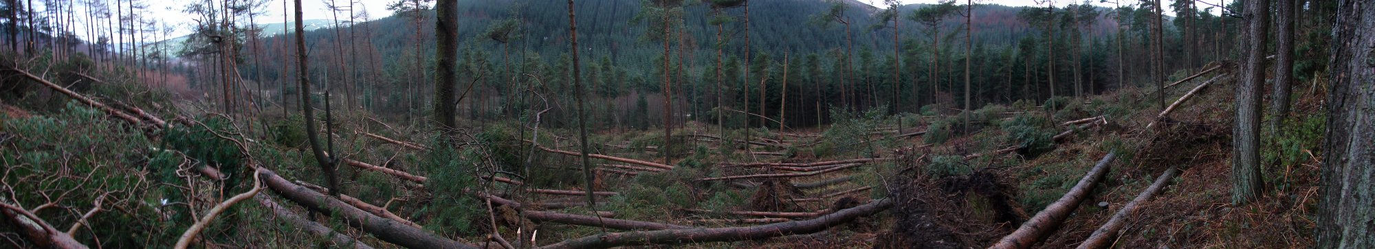
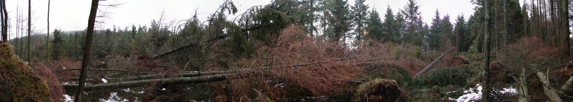
Bren ventured onto the right-hand valley side in order to obtain a good view back at the damage track. The photograph below shows a panoramic image of this view, as seen from the top of the opposite valley side. Click on the image for a larger annotated version, and click HERE to see the larger image without annotations.
Below are two zoomed images of Area 2 as viewed from the opposite hillside. The abrupt start of the damage track, and also the track width can be easily observed:
So what has created this narrow but intense track of devastation through the forests of Moel Famau? Valley funnelling is unlikely, as the damage is restricted to an elevated area of the left-hand valley side. This track, unusually, turns left and begins to ascend the valley side, before passing over the summit and into the neighbouring valley. Could this damage be the result of a massive vortex shedding event, where a large vortex was created from airflow over and around the summit of Moel Famau? All trees had fallen in the same direction as the track heading, albeit facing slightly upslope and to the left of the exact track direction. Despite there being no felling of trees evident in the opposite direction, a vortex may still be the driving force. The background winds were extremely strong on this date, and thus any vortex would have been travelling at great speed. It could be quite feasible for the left-flank of an anticyclonic vortex to create no damage, as the rotational velocity and translational velocities may cancel out. Other possible causes, however, may be just as feasible. Was a narrow but intense burst of wind deflected from a low level inversion? As this was deflected over the valley summit it could have maintained the power to destroy many trees, with surface friction being the driving force for the track's left turn. Whatever the cause, it was lucky that nobody was present at the time, as death or serious injury could have easily been the result. I would like to thank Dave Liddy, the local area manager for the Forestry Commission. Whilst no witness accounts exist, and thus the exact timing of the damage cannot be narrowed down within the day specified, the Forestry Commission representative was able to verify the date and the damage locations.
Copyright eye on the sky 2001-2008 |