Introduction
On 21st March 2004, a very unstable north-westerly airflow encompassed much of the UK, bringing widespread heavy showers. Many of these produced marked falls of hail, and several developed into thunderstorms. The conditions responsible for producing this convective outbreak were well-forecast in advance, so we made the decision to spend a day chasing across southern England. Having studied the forecast situation, we decided that the south-west Midlands and central southern England was the place to be - and we weren't disappointed!
During the evening, as we reached the Gloucestershire/West Oxfordshire border, a rapidly intensifying cell produced a violent thunderstorm with sizeable hail and very interesting characteristics. The storm resembled a weak supercell in nature, although we didn't want to jump to any conclusions.
This account offers a personal log of the climax to our day's storm chasing, and aims to put forward theories as to why this storm was unique. We are not offering sound scientific proof as to why we consider this storm to be super-cellular; they are only theories and observations and we welcome any feedback.
General Synoptic Background
Low pressure to the north of the UK gave a strong polar maritime flow across the United Kingdom. Advecting within this flow were several small upper cold pools, and associated trough disturbances. Many topographical and orographical effects also combined to produce areas of convergence, in particular the Cheshire Gap which, together with extended sea-track moisture intake, permitted large cell development across the Midlands. In addition to the flow characteristics, the late March sunshine promoted convective infill across the country, with individual cell growth during the mid-afternoon period. Countrywide, temperatures ranged from between 7-11°C (45-52°F), with low dewpoints of between 1-4°C (34-39°F) away from any showery activity.
Upper Air Data/Convective Characteristics
Conditions across central southern England are generalised from the interpolation of data from sonde ascents at Nottingham and Herstmonceux. As mentioned earlier, surface temperatures were around 9°C (48°F), with dewpoints no higher than 4°C (39°F) away from rainfall. Midday levels of Convective Available Potential Energy (CAPE) ranged from between 350-450J/kg across England, with around 170 J/kg of this in the lowest 3km of the atmosphere across southern parts of England. Tropopause heights were observed to be around 7000m, with freezing levels oscillating about 900-1000m. Levels of shear through the depth of the troposphere were not anomolously high; however degrees of low-level shear (in the lowest 1km) were quite significant. At surface level, mean wind speeds ranged from 0-20 knots across southern England, but ascents showed wind speeds of almost 40 knots at levels as low as 500-800m. Wind speeds increased linearly, from 40 to 100 knots, from this point up to 10km, across southern England. One final measure of the likelihood of thunderstorm development is the level of helicity, which although not huge through the troposphere as a whole, is significantly high in the lowest kilometre or so.
The following ascent data are for Nottingham and Herstmonceux at 11Z, with interpolation allowed for analysis later on.
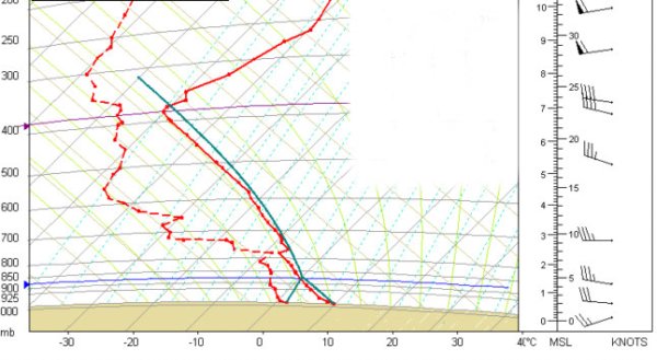
Nottingham ascent data.
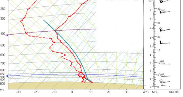 Herstmonceux
ascent data.
Herstmonceux
ascent data.
Favourable Conditions for Shallow Supercells
The conditions recorded at both sonde sites aren't indicative of severe thunderstorm development, although regional variations and local influence must be considered for cells elsewhere across the UK. Simplistically, supercells require many specific ingredients with which to form, including strong vertical wind shear and very high values of CAPE (and, in turn, updraft strength). Neither of these were present in the atmosphere during 21st March.
However, in an ever-researched area of science, mini-supercells may well be more common than originally thought. That is, at least, the idea we are subscribing to. The term "shallow supercell" is also known in the USA as a "mini-supercell", which is an accepted term used to describe smaller-scale versions of the large storms which roam the Great Plains during each spring. At a very basic level, the degree of supercell formation is a balance between the updraft strength and the level of shear. For a very strong severe supercell, very high levels of shear combined with explosive updrafts produce the tornadic monsters seen across the Plains. However, considering this notion of updraft strength versus vertical windshear, why can't reduced levels of both shear and updraft strength result in supercells which are weaker, but nevertheless ARE supercells? If this is the case, then the UK may well have more supercells per year than many would expect.
The following table displays upper air data measured in an atmosphere which produced a mini-supercell in Kansas in March 2000. This supercell produced a tornado rated F1 on the Fujita intensity scale, as well as large hail. Also in the table is data for the cell we encountered, interpolated from the sonde ascent.
| Parameter | Kansas Supercell | Burford Storm |
|
Energy Helicity Index |
0.2 | 0.2 |
| Boundary Layer to 6km Shear | 24 knots | 25 knots |
| LCL height (Lifting Condensation Level) |
161m | 550m |
| CIN | 2 J/kg | 0 J/kg |
| LFC Height (Level of Free Convection) |
284m | 620m |
| 0-3km CAPE | 307 J/kg | 170 J/kg |
Data from Jon Davies, Private Meteorologist, Wichita, KS (http://members.cox.net/jondavies1/LLbuoyprimer/LLbuoyprimer.htm)
Of course, it is immediately apparent that the degree of low-level CAPE is lower in the case of the Burford storm. However, under the correct conditions, tornadic supercells have formed with CAPE levels of less than 100 J/kg (see above web-site link).
The discussion here is a dramatically simplified view of supercell formation, and there are obviously other factors which can affect supercell development. However, we wanted to illustrate how the main contributing factors were satisfied in this instance, alongside other more unique characteristics which will be explained later.