Cader Idris - Snowdonia
Cader Idris forms a series of peaks at the most south-westerly point of the Snowdonia National Park, in north-west Wales. The highest point, Penygadair stands at 893m above sea level, and commands stunning views northwards across Snowdonia, and westwards across the Irish Sea. The mountain can be a severe place to be, exposed to the full elements of Atlantic storms. However, when climbed on calm summer days, the peaks are accessible to even inexperienced walkers. Despite this, wiith plenty of gaping crevices, large vertical cliff faces and often uneven ground, the mountain should not be underestimated.
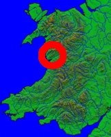
The following set of images follow a route I took in September, 2002, to reach the summit of Penygadair. The walk starts at the base carpark to the south of the uplands, near to the lake of Tal-y-Llyn (~90m above sea level). The car-park can be seen to the far south-east of the following map, and traces the footpath to Llyn Cau. From there, the path traverses the high ridge to the west of the lake, in a U-shape to the summit of Penygadair. The path continues eastwards to the second highest peak of Cader Idris, Mynydd Moel (863m), before rejoining the path back to the base car-park. Please click here to see an OS walking map of the route.