Cell Analysis - was this a supercell?
With our experience, and from the research we have since conducted into this system, our honest answer is "yes"! However, understandably and rightly so there will be vast scepticism about this verdict, particularly as the atmospheric conditions were not alarmingly in favour of such development.
However, we would like to put forward some summarising points as to why we believe this was the case.
- The
atmospheric conditions were not perfect, but did have interesting characteristics.
Helicity, shear and CAPE were all quite capable of sustaining supercell
development, provided other factors were met. There is a wealth of research
conducted in the USA into "mini-supercells", and in many instances
even tornadic supercells have formed in atmospheric conditions similar to
those seen across the UK on March 20th 2004. It must be remembered as well,
that the ascents at both Herstmonceux and Nottingham were over 7hrs earlier
and in vastly different locations. There was therefore plenty of scope for
the atmosphere to be modified both temporally and spatially, especially
with such a strong north-westerly flow.
- so based on this, could this have been a supercell?
Possibly, but rather unlikely!
-
However there is a trade-off, if one were to suggest the atmosphere could
not have sustained a supercell! Given the ascent data, there is little or
no chance of large hail production becoming a reality in any single or multicell
storms. Indeed, widespread thunderstorms occurred across Cheshire during
the afternoon, but these multicell storms rapidly grew and died, and could
not sustain hail larger than 5-8mm (0.3 inches at most) in diameter. The
cell we encountered did not have the benefit of being part of a multicell
complex, as it was without doubt a single-cell entity. Therefore, we put
forward the notion that a single-cell classic thunderstorm in such unfavourable
conditions, could not have maintained a long duration nor
produced such large hail. For this single cell entity to have remained solid
for nearly four hours, producing such impressive hail, supercell processes
must have occurred.
- so based on this, could it have been a supercell?
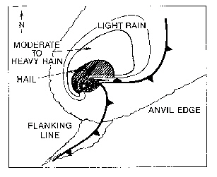
The evidence would suggest, yes! - In the quest to assign supercell status to this storm, we think that the structure of the storm is by far and large its greatest asset! Below is the classic supercell schematic:
...and
compared to the structure we observed from this cell...
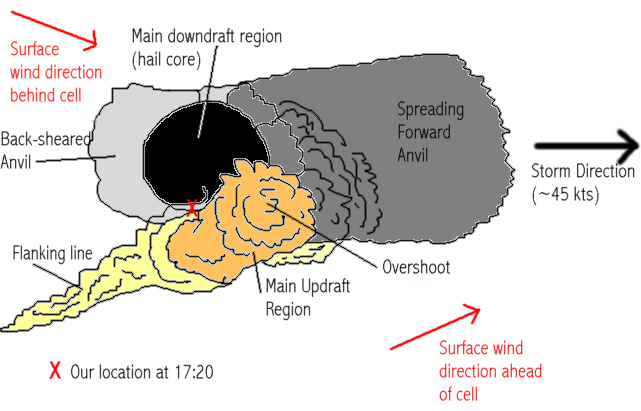
At face value, the similarities are remarkable. The flanking line feeding into the main updraft region was orientated almost exaclty as the conceptual model states, both the forward and back-sheared anvils are correct, and the heaviest precipitation downdraft is located correctly in relation to the rest of the storm. South to south-westerly winds at the surface ahead of the updraft are supported by the conceptual model, as are west to north-westerly winds behind the cell. But what about the precipitation set-up?
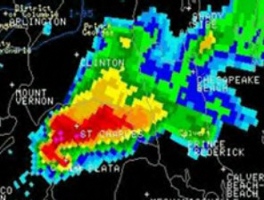
Below is an example radar image of the precipitation within a classic supercell, in the US:
For over an hour, this storm maintained a structure which can be summarised in the following radar slide:
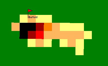
It is worth bearing in mind that the UK radar has a resolution of five square-kilometres, whereas that of the US radar image above has a resolution of just a few hundred square-metres, thus allowing greater detail to be seen. Besides this, the similarities between the classic supercell radar, and the radar slide from the Burford cell are quite obvious. Both have precipitation gradually becoming less intense from the core to the radiating anvil. Both have a well-defined core of heavier precipitation, comprising hail and heavy rain. For the most part, heavier precipiation tails off to lighter precipitation at the storm's extremities. However, in the classic supercell, the intense downdraft core at the rear of the storm is very abrupt, ranging from torrential falls to no precipitation over a very short distance. This marks the boundary line between the updraft and separated downdraft. In the case of the classic US supercell, this phenomena is associated with a "hook echo", as the downdraft spreads around the rotating mesocyclone. In the radar slide from this UK cell, a similar structure exists, and can be traced through several other radar slides displayed in this report. Once again, it is worth remembering that the radar resolution in the UK effectively "spoils" what could be a hook echo formation. Take the US radar image for instance. If that US cell occurred exactly as it was but in the UK instead, then one five-kilometre-square gridbox on the radar would cover both the thin red hook echo and the light precipitation vault region shown in green. Therefore, rather than displaying a detailed hook, it would show just one coloured block, averaged over the whole gridbox. It could well be that the most south-westerly black gridbox on the UK radar, representing >32mm/hr intensities, actually consists of a narrow hook of heavy precipitation (say 64mm/hr) and the light precipitation rotation centre (10mm/hr). Averaged over the whole grid-square, a singular 32mm/hr intensity would be shown. If it therefore did exist, could this apparent hook echo be evidence of cyclonic rotation, and thus an evident mesocyclone?
The Burford cell can be described as a High Precipitation (HP) thunderstorm. Therefore, at close-quarters with the storm, very little structure could be seen through the curtains of rain and hail. A rotating mesocylone could not therefore be visibly confirmed, and although radar signatures are very convincing, the true outcome could only be achieved through work with Doppler radar (which was not available).
- so, on the basis of the available data that we do have access to, could this storm have been a supercell?
We believe the answer is YES!
- Could
there have been local influences which allowed this storm to become a supercell
over the area? Was there local convergence? What about topography? Well,
there could be several theories involved with these questions. The storm
really intensified to maturity as it moved over the Cotswolds, and thus
the topographic uplift and flow disturbance may have played a part. Also,
the location of this area relative to the Bristol Channel may also have
been important. The westerly wind may have been funnelled into a more south-westerly
flow as it moved up the channel. When this narrow zone of south-westerly
winds exited the Bristol Channel canyon, they would have collided with the
westerly winds crossing South Wales. This may have caused local convergence
in the region in which the storm became severe.
However, the notions of local convergence are open to many many theories, which cannot really be proved due to lack of available data. For this reason, we will not explore these further.
- One startling characteristic of this cell was its eastward velocity, which made the storm impossible to "chase". The single cell travelled across the country at between 45 and 48 knots from birth to death, the speed applied by the upper level winds. Although the top of the storm travelled at comparable velocity to the upper level winds, the base of the storm would have been travelling substantially quicker than the surface winds. Indeed, the surface westerly winds were around 20 knots at most, suggesting that the storm was travelling some 25 knots faster. The result of this would be increased inflow to the front (east) of the storm, with this inflow reaching a speed of 20 knots westward relative to the storm's movement. Effectively, the inflow at the front of the cell would be the result of the cell itself literally piling into the air infront of it, and consuming it! This interesting factor may well have aided the setting up of rotation within the cell, effectively creating an counter-balance between the westerly winds behind the cell, south-westerly winds affecting the southern side of the cell, and now the relative easterly winds ahead of the cell. It may well be that the speed of the storm therefore played a large part in allowing it to become severe, even super-cellular.
So overall, there is a great deal of structural evidence to suggest this may well have been a shallow supercell. However, if there was just more characteristic of supercells that we could find evident, perhaps the case for this storm would be strengthened further...