Conclusions
This report was produced in order to explore all of the availabe data collected for the Burford thunderstorm. We've aimed to present an open collection of our thoughts into whether we believe this to be a supercell thunderstorm.
Whatever our own thoughts and conclusions, the truth will never been known without the aid of Doppler radar. This has, unfortunately, an extremely sparse spatial coverage in the UK, and it is becoming alarmingly obvious that the forecasting, tracking and research into British thunderstorms will not progress further without investment in a Doppler radar network.
However, we are inclined to believe that this was indeed a small, shallow supercell storm. One of the main hypotheses for this notion is that we encountered all manner of severe weather produced from this storm, in conditions which were not favourable to sustain them. In other words, there had to be some form of self-perpetuating system to allow the large hail, torrential rain, mass electrification and tornado to occur.
In summary, we believe this was a shallow supercell because:
- The cell had a duration of over two hours. This is important because one of the constituents in supercell definition is that the cell must last longer than it would take for a parcel to rise from the surface to the top of the updraft. The updrafts in this storm would have had to support hail of up to 25mm in diameter, and thus must have been strong enough to exceed the duration of the storm.
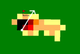
- The signature of the radar echo showed a structure which is characteristic of weak or shallow supercells, with a clearly defined anvil stretching some 30km ahead of the storm, and a core of heavy precipitation at the rear of the storm. The radar also showed the potential for a slight hook echo.
- The updraft and downdraft parts of the storm were completely separate, verified by both our own observations and photographs, and radar structure. The fact that the cell had lasted for over two hours is indicative enough of a separated updraft, thus not being quenched by the resulting downdraft. In fact, the storm only died due to lack of solar heating and warm inflow.
- Another supercell constituent is a persistent rotating mesocyclone, spanning at least two-thirds the depth of the thunderstorm. Now, because of the HP nature of the storm, rotation could not be verified simply by observation. However, once again the radar did indicate slight rotation, and the occurrence of the Filkins tornado added weight to this theory.
- The Filkins tornado itself occured in the region of the supercell one would most expect, assuming of course that this indeed was a supercell. This was to the south of the main downdraft, and was accompanied by the largest hail - again another observation made from US supercells.
- The general ascent data shown earlier would limit the formation of large supercells. However, data from weaker supercell events in the United States verifies that supercells can form in an atmosphere even less favourable than that over Burford!
So in summary, the cloud structure, radar, precipitation type and location, and T3 tornado formation all points in favour of a shallow supercell. The characteristics of the storm in terms of duration and surrounding atmopshere also indicate this may well have been supercellular.
Ultimately, without Doppler we simply won't know. We do hope however that this report and chase log will evoke a reaction in people, whether it be to research this further, or even present their own theories, however opposing.
We welcome all commments and suggestions, and we're planning to produce a subsequent page with any views and thoughts on whether this was indeed a tornadic supercell.
Please e-mail your comments to brenpebbs@aol.com.
One last coincidental piece of data, which we rather liked. Although this offers no conclusive proof, it's certainly interesting.
Back in January 2004, a large waterspout occurred in the Bristol Channel. Meteorologists are currently researching whether this may well have been a supercell, which developed in strong westerly winds.
Compare if you will, the radar image for the Bristol cell as it was producing its tornado, with the radar image of the Burford storm as its tornado was visiting Filkins...
The
Bristol storm
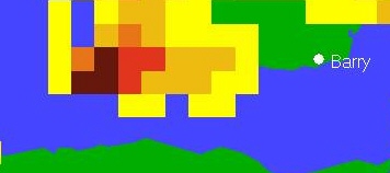
The
Burford storm
Coincidence?
Questions and comments to brenpebbs@aol.com.
Thank you for taking the time to read our report!
Please visit our comments and acknowledgements page.